Showing posts with label Native Americans. Show all posts

Saturday, March 22, 2014

Sedona, Arizona

Welcome to Sedona — "Arizona's Little Hollywood". Sedona was the location for more than sixty Hollywood productions from the first years of movie making through to the 1970s.

Aficionado’s of B-Grade Westerns (and a fair smattering of A-Grade shoot-em-ups), will recognise Sedona’s signature red rocks which featured prominently in dozens of Hollywood productions including Johnny Guitar, Angel and the Badman, Desert Fury, Blood on the Moon, and 3:10 to Yuma. Mind you, in these and many other movies the locations masqueraded variously as Texas, California, Nevada, and even the Canadian border territory.

When John Ford’s production of Stagecoach pulled into town in 1938, it kicked off thirty years of A-picture activity—some forty-four features through 1973. During those years, many of Hollywood’s biggest names were photographed in front of Sedona’s signature landscape, including Errol Flynn and John Wayne, and James Stewart, Robert Mitchum and Elvis Presley―to name just a handful.

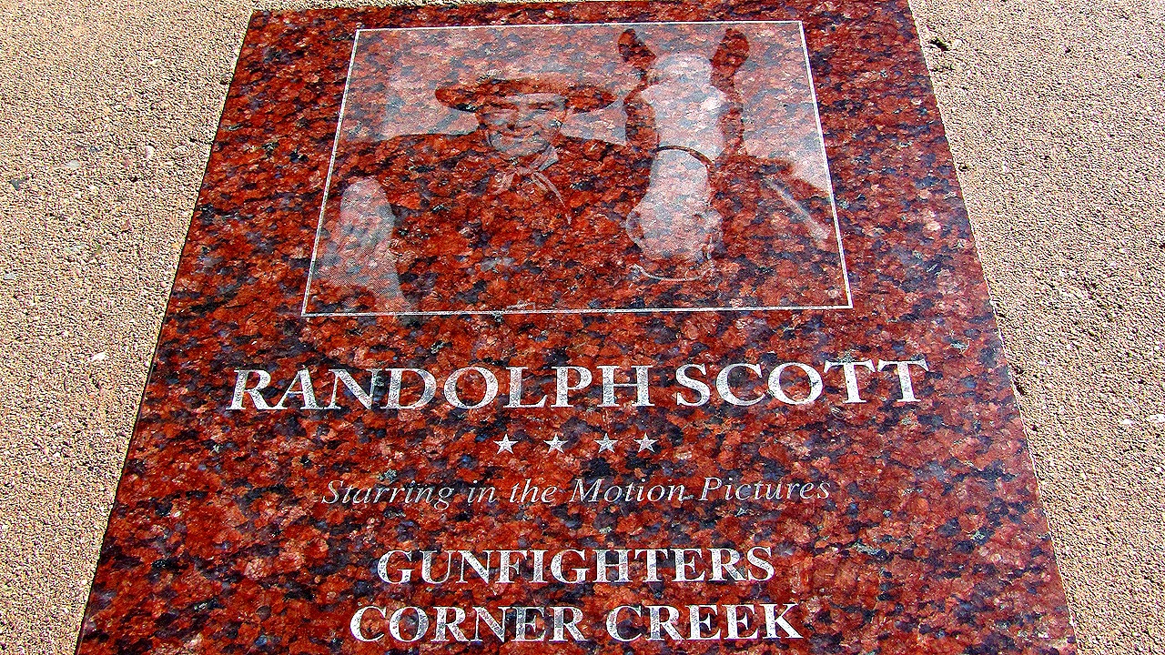
Located up and down both sides of Sedona’s main street are numerous tributes to the many well known actors and actresses who came to town to appear in the Westerns that helped make them famous. Each of these memorials features an image of the actor and a list of all the movies he or she appeared in.

If you are a movie buff, and especially if you like Westerns, a visit the Sedona Motion Picture Museum (in the town’s main street), is an absolute must if you want to learn more about this fascinating period in Sedona and Hollywood history.

By the by, Sedona was named to honor Sedona Arabella Miller Schnebly (1877–1950), the wife of Theodore Carlton Schnebly, the city's first postmaster. Sedona, the woman, was apparently celebrated for her hospitality and industriousness.

I also stopped by Slide Rock State Park. Originally the Homestead of Frank L. Pendley, who arrived in the canyon in 1907, Slide Rock State Park is a 43-acre historic apple farm located in Oak Creek Canyon. 

Penley’s pioneering innovation saw him create a unique irrigation system still in use by the park today. The park is named after the famous Slide Rock, a stretch of slippery creek bottom adjacent to the homestead. Visitors can slide down a slick natural water chute or wade or relax along the creek.

Native American History
Of course, long before Frank L. Pendley, arrived in the canyon, and long before Sedona Arabella Miller Schnebly, and the many Hollywood A-listers turned up, the first documented human presence in the Sedona area dated back to between 11500 to 9000 B.C., which by any measure makes these modern visitors (especially myself), Johnny-come-lately’s.

However, even native tribes were supplanted and replaced by a succession of other native peoples over these thousands of years. Paleo-Indians by the Sinagua people, who were in turn replaced by the Yavapai and Apache peoples. Thankfully, descendants of the Yavapai and the Apache are still with us today. Despite being forcibly removed from the Verde Valley in 1876, to the San Carlos Indian Reservation, 180 miles (290 km) southeast, about 200 Yavapai and Apache people returned to the Verde Valley in 1900. Today their descendants comprise the culturally distinct―but single political entity―now living in the Yavapai-Apache Nation.


More Information

Friday, July 5, 2013

Friday Photos: Monument Valley, Utah

Click images to view full sized
Friday 19, October, 2012 was the day I ‘died and went to heaven’, and here are the photos to prove it. Ok, so my idea of heaven may be different from yours, but I will take Monument Valley’s stunning landscape any day, over some mythical landscape in the hereafter.


The area is part of the Colorado Plateau. The elevation of the valley floor ranges from 5,000 to 6,000 feet (1,500 to 1,800 m) above sea level. The floor is largely siltstone or sand derived from it, most of which was left behind by the rivers that once carved out the valley. The vivid red colour comes from iron oxide exposed in the weathered siltstone, while the darker, blue-gray rocks in the valley get their colour from manganese oxide.


A very modest $5.00 will get you entry into the park, where the adventurous can embark on a 17-mile (27 km) dirt road route that passes some of the largest and most spectacular land formations.


The buttes are clearly stratified, and reveal three main layers. The lowest layer is known as the Organ Rock Shale, the middle is de Chelly Sandstone, and the top layer is the Moenkopi Formation.


More Information

Thursday, July 4, 2013

Monument Valley, AZ/UT

Words fail... Click to view full size
My travel journal entry for Friday 19, October, 2012 begins:

Today I died and went to heaven - and I have the photos to prove it.

Yes, that was the day I fulfilled a life-long ambition to visit Monument Valley. The valley spans the Arizona/Utah border, with the most iconic buttes and mesas on the Utah side. It was everything I expected it to be and more. Even in the middle of the day the setting was larger than life, with massive red monoliths dominating the landscape.

I had been driving my Dodge rental car up from Flagstaff, Arizona for several hours, watching as the landscape slowly changed from pine forested open country to vast expanses of dry desert covered in the valley's distinctive vivid red―a colour which is produced from iron oxide exposed in the siltstone covering the valley floor. In many respects the colour of the earth reminded me of the rich reds and ochres of the Australian outback, especially in an area often referred to as the ‘red centre’.

Welcoming billboard on the Arizona/Utah state line
Monument Valley (Navajo: Tsé Biiʼ Ndzisgaii, meaning valley of the rocks) is a region of the Colorado Plateau characterized by a cluster of vast sandstone buttes, the largest reaching 1,000 ft (300 m) above the valley floor. It is located on the Arizona-Utah state line near the Four Corners area. The valley lies within the range of the Navajo Nation Reservation, and is accessible from U.S. Highway 163. [Wikipedia…]
The American director, John Ford used the location for a number of his best known films, including his now classic 1939 movie, Stagecoach, and The Searchers, while the latest Hollywood film to feature scenes shot in the valley is The Lone Ranger, which coincidentally opens today in the cinema complex a few minutes walk from where I sit writing this.

One of the massive outcrops in Monument Valley

To my surprise, the cost to enter the park was a very modest $5.00. Once inside the park visitors can drive on a 17-mile (27 km) dirt road (a 2-3 hour trip) that passes some of the largest and most spectacular land formations. Guided tours are also available, as are horse rides and overnight camping trips. Apparently, hot air balloon flights are also available between May 1 through October 31, although I did not see any during my visit.

Sadly, my day trip to Monument Valley was over way too soon. The eleven hour round trip outing left me tired but exhilarated, and wanting much more. Far from removing the valley from my ‘bucket list’, the area remains among the top ten locations on the planet I want to visit or return to. When I do return to Monument Valley, I want to make the Navajo Tribal Park a major part of my experience, and I figure the only way to do that properly is find accommodations inside the Tribal Park.

Thankfully this is easily done following the construction of The View Hotel, located right inside Monument Valley.

The View Hotel [image courtesy The View Hotel website...]

The View Hotel is the only hotel located inside Monument Valley Navajo Tribal Park adjacent to the Monument Valley Tribal Park Visitors Center. Each of the hotel’s 95 rooms features a private balcony with unobstructed views of the valley floor, and the massive sandstone monuments that tower out of the stunning landscape.

Just writing and thinking about my visit, makes me want to pack my bag and catch the next flight to Los Angeles! But patience is the order of the day, at least until next year. Then all being well, I will make my return to the valley of my dreams.

More Information

Friday, June 14, 2013

Friday Photos: Montezuma Castle National Monument, AZ

Montezuma Castle National Monument 
Montezuma Castle National Monument is located in Arizona, approximately 140 km (87 mi) north of Phoenix, and about 80 km (50 mi) south of Flagstaff. I wrote more about my visit to the monument here, so for my Friday Photos feature today I thought I would post some more images from that amazing site.

Click images to view full sized
 ...
The Native Community
Numerous information panels provide interesting historical and cultural facts about the cliff-dwellings, and the surrounding landscape.

Mysterious Departures
The five-story stone and mortar dwellings contained 20 rooms and once housed about 50 people.

View of brickwork and roof supports
Neither part of the monument's name is correct. More like a prehistoric high rise apartment complex than a castle, the site was abandoned by the Sinagua 100 years before Montezuma was born.

Montezuma Castle National Monument

No access to the ruins themselves has been allowed since 1950 due to extensive damage of the dwelling, and the unstable nature of the limestone cliff face.

Diorama of cliff dwellings
This architecturally correct diorama gives visitors an idea of the internal layout of cliff-dwellings.

Diorama of cliff dwellings
Montezuma Castle National Monument was one of four original sites designated National Monuments by President Theodore Roosevelt in December 1906. The Monument was listed on the National Register of Historic Places in October, 1966.

Spectacular Cliff Dwellings in the Southwest 

Click images to view full sized.

More Information

Thursday, May 30, 2013

Montezuma Castle National Monument, Arizona

Montezuma Castle National Monument, Arizona
During my 2012 visit to the United States, I spent five nights in Flagstaff, Arizona, which I used as my base while I explored some of the surrounding country. During my stay, one of the locations I happened upon―as I headed somewhat randomly, south―was the Montezuma Castle National Monument, a short distance off Interstate 17. Phoenix is approximately 140 km (87 mi) south of the monument, and Flagstaff, is about 80 km (50 mi) north.

I had never heard of the monument before my visit, nor therefore, had I seen images of the site. To say I was awestruck by the size and scale of what turns out to be some of the best preserved cliff-dwellings in the American Southwest, is an understatement.

The cliff-dwellings at Montezuma Castle were built and used by the Pre-Columbian Sinagua people around 700 AD. The Sinagua were northern cousins of the Hohokam, and the site was occupied from approximately 1125 to 1400 AD, with peak occupation thought to be around 1300 AD. By the way, when European Americans discovered the cliff-dwellings in the 1860s, they named them for the Mexican Aztec emperor, Montezuma II, due to mistaken belief that the emperor had been connected to their construction. In fact, neither part of the monument's name is correct. The site was abandoned by the Sinagua 100 years before Montezuma was born, and the dwellings were not a castle. The building was more like a prehistoric high rise apartment complex.

Exactly why the Sinagua abandoned the cliff-dwellings is not known, but warfare, drought, and clashes with the newly arrived Yavapai people have been suggested. The five-story stone and mortar dwellings contain 20 rooms and once housed about 50 people. Nearby are the remnants of Tuzigoot (Apache for “Crooked Water”), a Singuan Village built on the summit of a ridge. Tuzigoot was two stories high, with 77 ground floor rooms that were accessible via ladders through roof openings. Unfortunately, little of this site has remained.

Montezuma Castle information panel
Due to its isolated location, only about 350,000 tourists visit the site each year. Access to the ruins themselves has not been allowed since 1950 due to extensive damage of the dwelling, and the unstable nature of the limestone cliff face. However, there is a paved trail that leads from the visitor centre and skirts the base of the cliff containing the ruins, from which excellent views of the dwellings can be seen. In addition, numerous information panels (like the one seen at right) provide interesting historical and cultural facts about the cliff-dwellings, and the surrounding landscape.

The dwellings and the surrounding area were declared a U.S. National Monument on December 8, 1906 as a result of the American Antiquities Act, signed earlier in June of the same year. It was one of the four original sites designated National Monuments by President Theodore Roosevelt. The National Monument was listed on the National Register of Historic Places on October 15, 1966.

If you are visiting Montezuma Castle, allow time to visit Montezuma Well several miles away. The well is a limestone sink created by the collapse of a large underground cavern, which is fed by permanent springs. There are also ruins located here from large pueblos to one-room houses.

What You Need To Know
> Operating Hours & Seasons
Open Daily: 8:00 AM-7:00 PM in summer, and 8 AM-5 PM in winter.
Closed on Christmas Day.
Phone: (928) 567-3322

Model depicting internal layout of cliff-dwellings
Montezuma Castle Entrance Fees
Adults (16 and over): $5.00 (good for seven days)
Children (under 16): FREE. Entrance fees for Montezuma Castle are collected inside the park Visitor Center during normal business hours.

Passes are available at a discounted rate of $8.00 for both Montezuma Castle and Tuzigoot National Monuments.

More Information

Sunday, October 16, 2011

The Viewing List 7

Ishi, The Last Yahi
Years ago I read a book called Ishi, The Last of His Tribe. It tells the story you can see in the video embedded below. A story both shocking and poignant about this Native American who was the last surviving member of his tribe, the Yahi.

The Snag Films website from where I have sourced this video states: In 1492, there were more than ten million Native Americans in North America. By 1910, their numbers had been reduced to fewer than 300,000. In California, massacres of Indians in the 1860s and 1870s had nearly exterminated the Native peoples in the state.

Therefore the sudden appearance in northern California in 1911 of Ishi, "the last wild Indian in North America," stunned the nation. For more than 40 years, Ishi had lived in hiding with a tiny band of survivors. When he walked into the white man's world, he was the last Yahi Indian alive.

If the story wasn’t true it would surely be unbelievable, but true it was, as this documentary shows.

Click here to see Ishi, The Last Yahi...  Make sure you click on the Full Screen icon at the bottom right of the video for optimal viewing.

-o0o-

I’ve never been to India, and although I might make the journey there one day, it is not high on my ‘bucket list’. However, I know people who have been to India, and loved the country, the food, the culture and its people, and that keeps the idea of a visit alive in the back of my mind somewhere.

Hongkiat.com (Online Tips For Designers and Bloggers) has collected together 40 Beautiful Photos of India, and they are indeed beautiful.

As the site states: "India is so vast and full of variety that even the Indians don’t get to see the whole of it, let alone the tourists. You have to visit the place to know it. However, the photographs give you a good idea of how the place looks and how it should feel like. It also helps you to decide what places you want to visit when you are planning a trip to India."

Thanks to Paul Steele (Twitter: @paul_steele) for bringing these to my attention.

Monday, August 3, 2009

In Review: Great Plains


Click here to order from Amazon.Com
~ “Away to the Great Plains of America, to that immense Western short-grass prairie now mostly plowed under! Away to the still-empty land beyond newsstands and malls and velvet restaurant ropes!”

So begins Great Plains, the 1989 examination of America’s heartland. That vast inner expanse of plains and prairies that range from Canada in the north down to the Texas panhandle in the south. Stretching some 2500 miles in length, and about 600 miles across at their widest point, the Great Plains encompass parts of the Canadian provinces of Alberta, Saskatchewan, and Manitoba, and parts of the American states of Montana, North and South Dakota, Wyoming, Nebraska, Colorado, Kansas, New Mexico, Oklahoma and Texas.

Part history, part travelogue, part extended road trip, Great Plains has the grandeur and sweep of the frontier itself crammed into its concise 214 pages of main text – which is no mean feat, let me tell you.

By the time he wrote this book, Ian Frazier had driven some 25,000 miles on the plains – from Montana to Texas and back again. Twice. As well as many shorter distances. His meanderings took him from an abandoned anti-ballistic-missile system command centre in remote Montana, to the exact site of Bonny and Clyde’s automobile plunge into the Red River; from the location of Sitting Bull’s camp on the Grand River, to the site of Custer’s last stand on the Little Big Horn; from Fort Union in North Dakota, to Fort Stockton in Texas.

It is no accident that rivers feature so much in this book – even as peripheral ‘characters’. The Great Plains are at times so dry and barren that in the early years of exploration parts of them were known as the Great American Desert. It made sense for the early settlers – just like Native Americans – to build their forts and villages, their towns and cities along the banks of any river large enough to provide a source of life-giving water and food to the populace.

No accident too, that the history of conflict between Native American Indians and settlers crops up throughout Great Plains. Frazier manages to examine the slaughter of millions of bison, the betrayal and death of Crazy Horse, and meet and mix with numerous descendents of the great warriors of the past as he traverses this immense space.

All the great characters are here; ranchers and homesteaders, mountain men and fur trappers, outlaws and gangsters, cowboys and Indians, railroad barons, oil men, coal miners, and more. You get to meet the great and humble, the rich and poor, emigrant Germans and former Southern Black slaves, and the men and women who struggled for generations (and who still struggle today), to make some sort of living from the Great Plains.

Ian Frazier is clearly a man in love with the Great Plains, its history, and its immense cast of fabulous characters – both modern and ancient. As an introduction to this vast area of land and open space Great Plains is entertaining and informative, and filled with insight, obscure historical facts and references, and ultimately, immensely readable.

Finally, the book is well indexed, includes 16 pages of black and white photographs, and has almost 70 pages of extensive notes to supplement the main text. Highly recommended.

“This is a brilliant, funny, and altogether perfect book, soaked in research and then aired out on the open plains to evaporate the excess, leaving this modern masterpiece. It makes me want to get in a truck and drive straight out to North Dakota and look at the prairie.” —Garrison Keillor

Click here to purchase Great Plains via Amazon.Com...
Great Plains by Ian Frazier (First published: 1989, Penguin Books)
Now available in Picador (May 4, 2001) . ISBN-10: 0312278500

Also by Ian Frazier is the book On the Rez, billed by Amazon.Com as “…a history of the Oglala nation that spotlights our paleface population in some of its most shameful, backstabbing moments, as well as a quick tour through Indian America. Much of On the Rez revolves around Le War Lance, whom Frazier first met in Great Plains.”

Publisher: Picador; 1st edition (May 4, 2001). ISBN-10: 0312278594

NOTE: scroll through the Reading List box on the left to purchase On The Rez directly from Amazon.Com. You can also click on the In Review tag below to view other book reviews on this site.
Related Posts Plugin for WordPress, Blogger...